Round and Round the Satellites Go
Do you watch satellite television? Enjoy your weather situation being monitored? Have you ever used a satellite telephone? Have you ever thought about how these things are made possible?
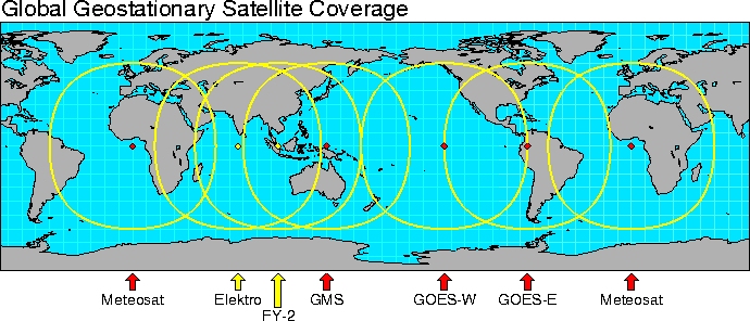
Most of us in equatorial or mid-latitudes take for granted our access to continual access to satellite imagery that is used for meteorological observations as well as various types of communications. The Discovery Channel programming that might be playing on the television beside may very well be coming from a satellite. These types of satellites, geostationary satellites, appear to sit in an apparent stationary position relative to Earth as the earth rotates. How is this possible? At an orbit of 22,300 miles above the earth, a satellite orbiting around Earth will appear to be stationary to the observer on the ground. The closer a satellite’s orbit is to the earth, the faster its orbit around the earth; the father away, conversely, the slower its orbit becomes. But, that sweet spot at 22,300 miles allows the satellite to orbit at the same speed that Earth does, and therefore provides the aforementioned satellites continual visibility to the area directly underneath said satellite and allows your TV satellite dish to be able to be able to continually point directly at it and allow you to enjoy your television programming.
Image source: pcmag.com
But, a geostationary satellite becomes blind above 62 degrees latitude. This is any geostationary satellite, that is to say a satellite in geostationary orbit, regardless of its build or construction. Radio communications can no longer reliably reach said satellites, nor can said satellites provide adequate visibility to those areas. So, what do individuals residing above that latitude line do when they require access to communications and weather satellites?
One solution is a low-earth orbit satellite put in a polar or near-polar inclination. That means that these satellites travel very quickly around the earth from north to south, or south to north. This is ok, but provides only a short period of time when the ground area desired to be observed is visible; the same goes for communications abilities in these areas. Imagine, for example, a satellite like an airplane; it passes overhead rather quickly. In the case of a satellite, the satellite may be communicated with (and can visualize ground area it is intended to see, depending on its mission) more or less within line-of-sight…when it is directly overhead the area of interest. Once it travels away from its swath area, it has to travel all the way around the globe before it “repeats” back into that position again. One solution is to put many satellites in this orbit, which can be an expensive and difficult to manage proposition.
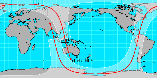
Another solution that started being put into practice during Soviet times is the Molniya (lightning) orbit originally developed and used by Russia on 23 April 1965. This orbit has a high eccentricity, which means instead of looking like a circle, it looks more like an oval. The part of the oval closest to earth, the perigee, is put as close as feasible to earth, while the apogee stretches far beyond earth. This allows the satellite a maximal amount of dwell time above the intended target area, allowing for longer coverage of said area with that one satellite. Maximal dwell time in this case is defined as maximizing the amount of time this satellite sits above a desired position within its orbit. Remember that, in the case of TV or communications satellites, the satellites need to stay within a line of sight area to target to maintain communications or imagery capability with the target This means that the satellite needs to be directly above the area over which it collects / exchanges information.. This means fewer satellites are needed to achieve the same mission as compared to a low earth orbit satellite cluster. Genius!
Take a look at this interesting video demonstrating the Molniya orbit, as if the viewer was sitting atop the orbiting satellite:
Acknowledgements:
National Center for Atmospheric Research, & Johnson, D. B. (1996, June 7). Satellite Coverages and Orbits. Retrieved from https://ral.ucar.edu/~djohnson/satellite/coverage.html
Trishchenko, A. P., Garand, L., Trichtchenko, L. D., & Nikitina, L. V. (2016). Multiple-Apogee Highly Elliptical Orbits for Continuous Meteorological Imaging of Polar Regions: Challenging the Classical 12-h Molniya Orbit Concept. Bulletin of the American Meteorological Society, 97(1), 19–24. doi: 10.1175/bams-d-14-00251.1
Wade, M. (2019). Molniya-1. Retrieved from http://www.astronautix.com/m/molniya-1.html
Vocabulary list
Geostationary: Stationary relative to the earth, in this case. This means the rotation of the satellite matches the rotation of the planet, making the satellite appear to not move relative to the viewer on the ground.
Apogee: The farthest point within an orbit, in this case, our satellite(s)
Perigee: The closest point within an orbit, in this case, our satellite(s)
Conversely: A statement that reverses a statement that has just been made
Eccentricity: How “stretched out” the orbit of a satellite is, like an oval, as opposed to being circular
Stationary: Not moving
Put into practice: To commence doing, whereas before perhaps only discussed
Residing: To be situated in
Latitude line: a geographic coordinate that specifies the north–south position of a point on Earth's surface
Inclination: Angle of orbit relative to Earth’s equator
Apparent stationary position: Not moving relative to the viewer
Aforementioned: Just mentioned, as mentioned before
Swath area: The area underneath the satellite that is able to be photographed, in the case of satellite imaging payloads, or able to be communicated with, in the case of communication payloads
ABOUT THE AUTHOR
Nicholas Chudolij is graduate student within American Public University's Space Studies faculty, Astronomy track. Nicholas loves traveling, fishing, competitive marksmanship and playing the flute.


